
description Willoughby Spit Overview
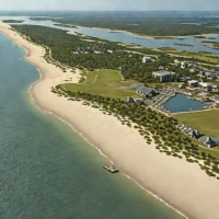
Willoughby Spit is a narrow peninsula and beach area in Norfolk, Virginia, bordered by the Chesapeake Bay and Willoughby Bay. A hurricane in October 1749 pushed a large sand spit into the waters near Sewell’s Point, beginning the landform’s development, while later storms, especially the 1806 hurricane, enlarged and reshaped it. The area remains exposed to coastal erosion, storm surge, and changes in the shoreline.
help Willoughby Spit FAQ
Where is Willoughby Spit?
Willoughby Spit is a narrow peninsula and beach area in Norfolk, Virginia. It lies between the Chesapeake Bay and Willoughby Bay near Sewell's Point.
How did Willoughby Spit form?
A hurricane in October 1749 pushed a large sand spit into the waters near Sewell's Point. Later storms helped shape and extend the landform.
Is Willoughby Spit a natural or built landform?
Its origin is natural and strongly connected to storm-driven coastal sediment. The peninsula has since been shaped by later storms, waves, erosion, and human development.
Why is Willoughby Spit vulnerable to storms?
It is a narrow, low-lying coastal sand body exposed to the Chesapeake Bay and nearby open water. That setting makes storm surge, erosion, and changes in the shoreline important local concerns.
explore Explore More


Reviews & Comments
Write a Review
Be the first to review
Share your thoughts with the community and help others make better decisions.


