
description Mercator Atlas Overview
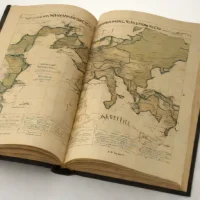
Gerardus Mercator's map collection appeared in 1595, published after his death through the work of his son Rumold. It gave the term atlas its influential use as the title of a geographical map book. The volume brought carefully engraved maps together with a broader account of the world, making it an important work in the development of European cartography. Although Mercator's name is strongly associated with the conformal projection used in navigation, that projection does not feature in this atlas.
Its world map uses paired hemispheres instead, and the collection's geographical coverage is uneven rather than complete. These distinctions make the book useful for understanding Mercator beyond his best-known invention. Historians and geographers can examine how regional mapping and editorial decisions shaped the volume, while readers interested in early mapmaking can compare its representation of the world with later atlas traditions.
help Mercator Atlas FAQ
When was the term "atlas" first used for a collection of maps?
The term "atlas" to describe a bound collection of maps was first coined by Gerardus Mercator in 1595. He used the name of the mythical Greek titan Atlas, whom he depicted on the title page bearing the weight of the heavens.
Who published the original Mercator Atlas?
The original "Atlas" was compiled by the Flemish cartographer Gerardus Mercator, but it was actually published posthumously by his son Rumold Mercator in 1595. Gerardus had died a year prior in 1594 after years of painstaking geographic and mathematical work.
What map projection did Gerardus Mercator famously invent?
Gerardus Mercator famously introduced the Mercator projection in 1569, well before his 1595 atlas. This cylindrical map projection represents lines of constant bearing as straight segments, which revolutionized maritime navigation by allowing sailors to plot straight-line courses.
Why is the Mercator Atlas historically significant?
The 1595 Mercator Atlas is historically significant because it was the first time a book of maps was explicitly designed and titled as an "Atlas" with a uniform structure. It established the modern convention of binding geographic maps together into a single, systematic volume.
explore Explore More



Reviews & Comments
Write a Review
Be the first to review
Share your thoughts with the community and help others make better decisions.


