
description Stieler's Hand-Atlas Overview
Stieler's Hand-Atlas is a historically significant German world atlas originally created by cartographer Adolf Stieler. First published by the Justus Perthes Geographical Institute in Gotha in 1817, it became the standard geographic reference work for the German-speaking world throughout the 19th century. The atlas underwent numerous revisions and expansions, culminating in a highly detailed international edition in the late 19th and early 20th centuries.
help Stieler's Hand-Atlas FAQ
Who published Stieler's Hand-Atlas?
"Stieler's Hand-Atlas" was published by the prominent German publishing house Justus Perthes, located in Gotha. The firm was highly respected in the 19th century for its meticulous geographical and cartographic works.
When was the very first edition of Stieler's Hand-Atlas published?
The first edition of the atlas was published in 1817, originally created by the German cartographer Adolf Stieler. The original 1817 edition contained far fewer maps than the later, highly detailed 19th-century editions.
How many maps were in the final edition of Stieler's Hand-Atlas?
The later editions, specifically the famous 9th and 10th editions published in the early 20th century, contained well over 100 detailed double-page maps. This massive undertaking made it one of the most comprehensive geographic reference works of its era.
Did Adolf Stieler work alone on the atlas?
No, Adolf Stieler collaborated with other cartographers like Friedrich von Stülpnagel to create the initial maps. Following Stieler's death in 1836, other editors and cartographers at Justus Perthes continued updating and expanding the atlas for over a century.
explore Explore More
Similar to Stieler's Hand-Atlas
compare_arrows Compare: Meyers Großer Handatlas See all arrow_forward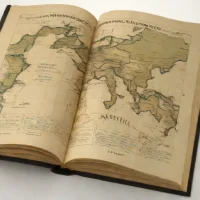


Reviews & Comments
Write a Review
Be the first to review
Share your thoughts with the community and help others make better decisions.


