
description Elgeyo Escarpment Overview
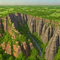
The Elgeyo Escarpment is a prominent geological fault scarp located in the western part of Kenya. It forms the western wall of the Eastern Rift Valley, dropping sharply to the Kerio Valley below. The escarpment rises to elevations exceeding 2,000 meters above sea level and is heavily forested on its upper slopes. The region is known for its high-altitude athletics training camps, which take advantage of the plateau's steep terrain and thin air, and it serves as a natural boundary between counties in the region.
help Elgeyo Escarpment FAQ
Where is the Elgeyo Escarpment located?
The Elgeyo Escarpment is a major geological fault scarp located in the Rift Valley Province of Kenya. It forms the dramatic western wall of the Kerio Valley.
How high does the Elgeyo Escarpment rise?
The escarpment rises dramatically to over 1,800 meters (about 5,900 feet) above the Kerio Valley below. This massive elevation drop creates breathtaking views and highly distinct microclimates.
What river runs along the base of the Elgeyo Escarpment?
The Kerio River flows northward through the valley at the base of the escarpment. The river eventually empties into Lake Turkana, the world's largest permanent desert lake.
What geological forces created the steep cliffs of the Elgeyo Escarpment?
Like other features in the Great Rift Valley, the Elgeyo Escarpment was formed by tensional forces pulling the earth's crust apart. This massive stretching caused large blocks of land to drop down, leaving steep, exposed fault lines.
explore Explore More



Reviews & Comments
Write a Review
Be the first to review
Share your thoughts with the community and help others make better decisions.


